


Aerial Photo Documentation for Insurance Claims
Capture time-stamped aerial imagery for insurance claims, protecting you, your clients, and your properties. BuzzBot Drone’s certified drone operations are particularly useful for roofing, high elevations, or unsafe areas—eliminating the need for anyone to climb ladders or walk fragile surfaces.
We provide professional-grade documentation formatted to help insurance providers process your claim faster and more efficiently — with all the key data they typically request, organized in a clean and review-ready package.
📋 Why Choose BuzzBot Drone for Insurance Documentation?
Precision Time Stamps & Geo-Tagging
Every aerial image is automatically timestamped and geolocated, providing unassailable proof of property condition on the exact date and time it was captured.
Safest Inspections
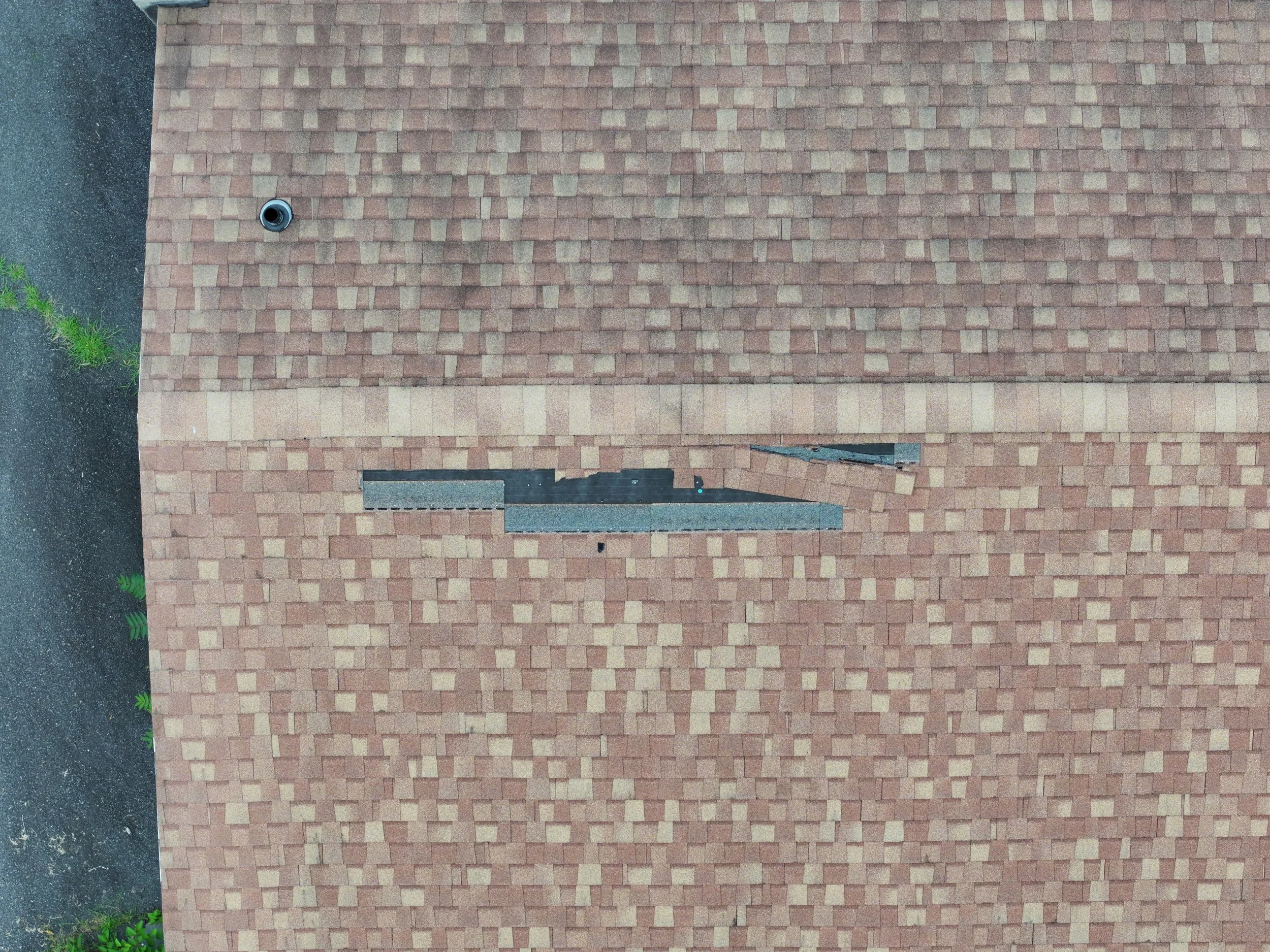
No personnel need to walk on risky roofs or enter unsafe environments—our drones handle the job without exposing adjusters or homeowners to danger.
Faster Claims Processing
High-resolution aerial photos, uploaded upon landing, give insurance companies immediate visibility—reducing inspection time from days to hours.
Complete Roof & Property Coverage
Our 80% overlap flight method captures every angle of roof surfaces and property features, eliminating blind spots and providing comprehensive inspection data.
Time-Based Comparisons
Capture seasonal or storm-event imagery to compare side-by-side visuals, proving pre-event condition and simplifying claim validation.
Irrefutable Visual Proof
Our standardized flight paths and photo capture methods create consistent, repeatable imagery—making your case stand up in claims and court.
Easy-to-Navigate Delivery
Clients receive a polished PDF report, annotated images, and an optional web-viewer for quick review—streamlined for homeowners, adjusters, and contractors.
Cost-Effective & Efficient
Drone-based inspections are faster and cheaper than man-lift or rope-access crews, lowering costs and accelerating the claims timeline.
🛠️ Common Insurance Use Cases
Roof Damage Documentation after storms (hail, wind, debris)
Exterior Building Assessments for siding, windows, gutters
Tree & Vegetation Claims impacting your property
Post-Construction Completion Checks before occupancy
Fire, Flood, or Impact Damage with inaccessible zones
✅ What You Receive with Every BuzzBot Mission
Time-stamped, high-resolution aerial photos (JPG + geospatial metadata)
Orthogonal PDF summary with scale bars and compass alignment
Roof slope and elevation overview for structure-specific claims
Optional 3D fly-through web viewer for adjusters and engineers
Photographic record for pre- and post-event comparison
Licensed deliverables formatted for adjuster use — no additional software required
⚠️ Important Note for Insurance Documentation Clients
Every provider may have unique documentation requirements.
We recommend verifying with your insurance company to ensure the deliverables listed meet their specific standards.
If additional images, data formats, or capture angles are required, we’re happy to adapt and return to the site to get exactly what your adjuster needs.
📦 Insurance Documentation Packages & Pricing starting at:
🟢 Basic Visual Package – $225
Perfect for small homes or single roof/structure claims.
Includes:
10+ time-stamped aerial photos
Orthographic top-down views (roof and property GeoTiff)
PDF summary with north arrow and scale bar
48-hour delivery (usually 12 to 24 hours)
🔵 Standard Insurance Package – $375
Best for full property assessments or moderate weather damage.
Includes:
20+ aerial photos (roof, siding, tree line, etc.)
Oblique views from multiple elevations
PDF report with annotations and geotag info
Optional web-based viewer link
48-hour delivery (usually 12 to 24 hours)
🔴 Comprehensive Claim Package – $595
Ideal for major events (hail, flood, wind), inaccessible structures, or full adjuster-ready documentation.
Includes:
30+ aerial and close-range detail shots
3D terrain or roof elevation map (when applicable)
PDF claim-ready summary with overview + timestamped media
Optional custom visuals for contractor/adjuster use
Web-based viewer + digital delivery folder
48-hour delivery with priority scheduling (usually within 24 hours)
🛠️ Add-Ons (Available with Any Package):
🔸 Post-Event Follow-Up Flight – $125
(Great for before/after insurance comparison)
✔️ All imagery is licensed, timestamped, and geotagged
✔️ Deliverables formatted for homeowner and adjuster use
✔️ Need something else? We’ll customize it for your provider’s specs
Book Your Insurance Inspection Today
Protect your property and reduce your liability—schedule a professional drone-based inspection with BuzzBot Drone for fast, safe, and transparent insurance documentation.
📧 Email: info@buzzbotdrone.com
📱 Call/Text: (570) 290‑7286
